
Designing the SUDOANG spatial database
In order to carry out a comprehensive eel assessment in the SUDOE area, standardisation of data collection and assessment methods between different states is needed. In SUDOANG, we have coordinated between working groups and managers to gather all the scattered information about the abundance, distribution and biometries of eel, as well as the characteristics of the basins in which it lives.
The first step was to create templates to collect the information, which were presented and delivered during the kick-off meeting. Currently, all providers have sent the information available in their area.
All data received are being compiled in the SUDOANG database, whose structure is inherited from the Eel Database (DBEEL), developed during the POSE Project. Its objective was the current and potential estimation of silver eel in the North Sea-Baltic, Atlantic and Mediterranean regions. DBEEL provides a practical and cost-effective solution for the management and exchange of information on the species. Its structure can be adopted at different spatial scales, supporting coordinated eel assessment and management. For these advantages, the SUDOANG database maintains the same structure, based on a main network defined by:
– The observation place that refers to the hydrographic network, where all the environmental characteristics of the hydrographic network of the SUDOE area are collected. Thanks to this structure, other elements such as basins or lakes can also be stored.
– The observations that correspond to the general characteristics of:
- scientific observations: in our case, electric fishing,
- the impact of pressures: such as physical obstacles or dams, which can have a hydroelectric plant/s associated with their respective turbines.
– The batch or set of individuals grouped by taxon and life phase, which are sampled during the observation.
– The biological characteristics that characterize each lot, such as age, sex, length or weight.
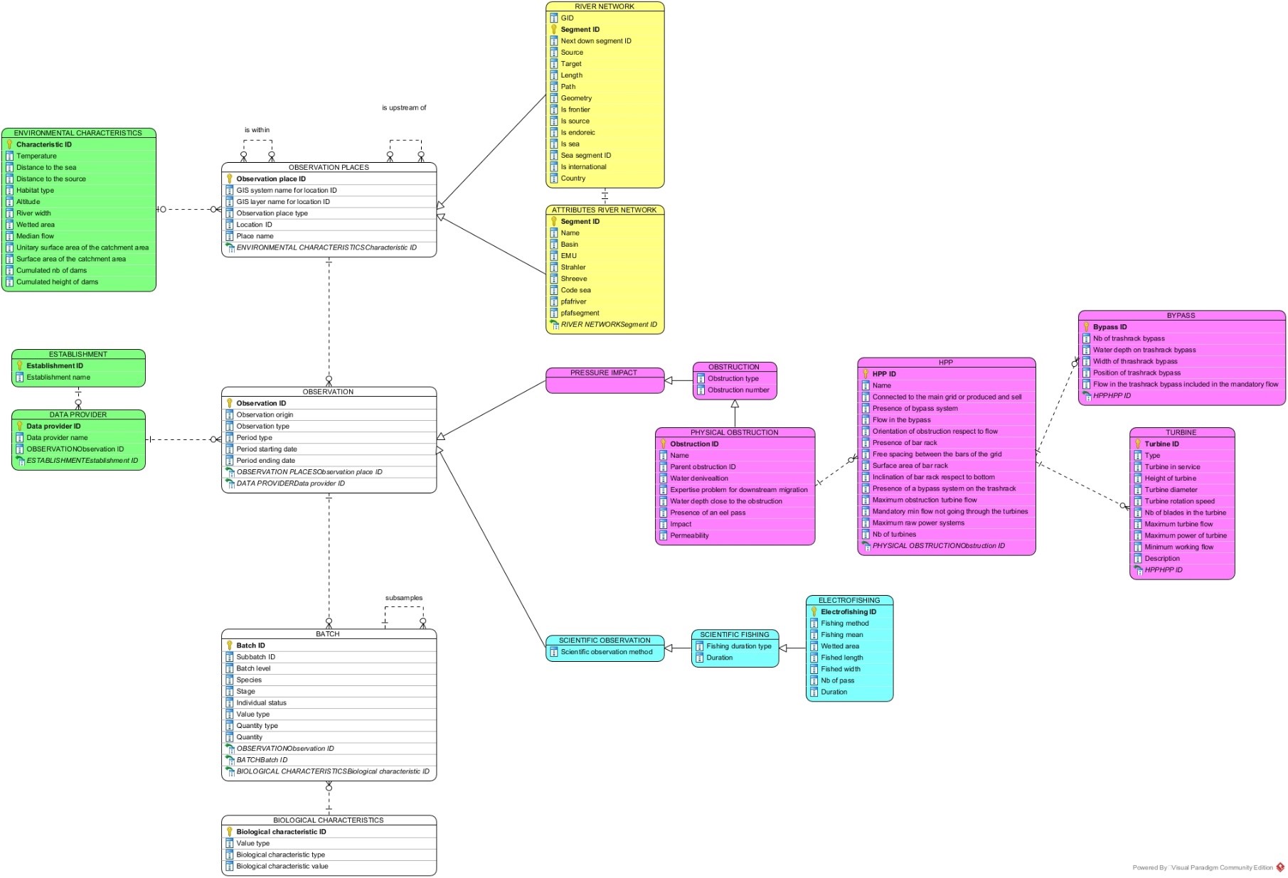
In the conceptual model (figure 1) this structure can be observed, which is also described in a data dictionary. From this database, different information can be extracted, for example:
- The distance to the sea that will be used as an environmental variable to estimate eel abundance in rivers (Figure 2.A).
- The electrical fishing stations carried out to estimate the abundance of eels and that will create an atlas of the entire SUDOE area (figure 2.B).
- Obstacles to determining which ones impede eel migration, and whether there are associated hydroelectric plants whose turbines have a negative effect on the species (Figure 2.C).

Once the import of all available information is complete, other models we are developping ( such as estimation of obstacle mortality and escape) will be implemented.
We will keep you informed of our progress!